- Page 1
- Page 2
- Page 3
- Page 4
- Page 5
- Page 6
- Page 7
- Page 8
- Page 9
- Page 10
- Page 11
- Page 12
- Page 13
- Page 14
- Page 15
- Page 16
- Page 17
- Page 18
- Page 19
- Page 20
- Page 21
- Page 22
- Page 23
- Page 24
- Page 25
- Page 26
- Page 27
- Page 28
- Page 29
- Page 30
- Page 31
- Page 32
- Page 33
- Page 34
- Page 35
- Page 36
- Page 37
- Page 38
- Page 39
- Page 40
- Page 41
- Page 42
- Page 43
- Page 44
- Page 45
- Page 46
- Page 47
- Page 48
- Page 49
- Page 50
- Page 51
- Page 52
- Page 53
- Page 54
- Flash version
© UniFlip.com
feature stories | flood protection for mina
flood protection for mina
by Mohamed Monkachi and Ahmad S. Hassaballah, R&E
Saudi Arabia is one of the most arid countries in the world, but severe rainstorms are surprisingly common in the mountainous region along its western coast. Reported torrential rains in the past have caused severe flash floods, destroyed homes and resulted in casualties.
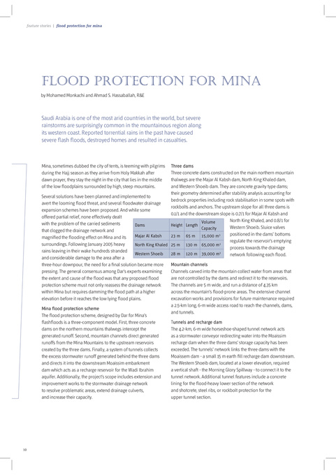
Three dams Three concrete dams constructed on the main northern mountain thalwegs are the Majar Al Kabsh dam, North King Khaled dam, and Western Shoeib dam. They are concrete gravity type dams; their geometry determined after stability analysis accounting for Several solutions have been planned and implemented to bedrock properties including rock stabilisation in some spots with avert the looming flood threat, and several floodwater drainage rockbolts and anchors. The upstream slope for all three dams is expansion schemes have been proposed. And while some 0.1/1 and the downstream slope is 0.7/1 for Majar Al Kabsh and offered partial relief, none effectively dealt North King Khaled, and 0.8/1 for Volume with the problem of the carried sediments Dams Height Length Western Shoeib. Sluice valves Capacity that clogged the drainage network and positioned in the dams’ bottoms 3 Majar Al Kabsh 23 m 65 m 15,000 m magnified the flooding effect on Mina and its regulate the reservoir’s emptying surroundings. Following January 2005 heavy North King Khaled 25 m 130 m 65,000 m3 process towards the drainage rains leaving in their wake hundreds stranded Western Shoeib 28 m 120 m 39,000 m3 network following each flood. and considerable damage to the area after a Mountain channels three-hour downpour, the need for a final solution became more Channels carved into the mountain collect water from areas that pressing. The general consensus among Dar’s experts examining are not controlled by the dams and redirect it to the reservoirs. the extent and cause of the flood was that any proposed flood The channels are 5 m wide, and run a distance of 4.35 km protection scheme must not only reassess the drainage network across the mountain’s flood-prone areas. The extensive channel within Mina but requires damming the flood path at a higher excavation works and provisions for future maintenance required elevation before it reaches the low lying flood plains. a 2.5-km long, 6-m wide access road to reach the channels, dams, Mina flood protection scheme and tunnels. The flood protection scheme, designed by Dar for Mina’s Tunnels and recharge dam flashfloods is a three-component model. First, three concrete The 4.2-km, 6-m wide horseshoe-shaped tunnel network acts dams on the northern mountains thalwegs intercept the as a stormwater conveyor redirecting water into the Moaissim generated runoff. Second, mountain channels direct generated recharge dam when the three dams’ storage capacity has been runoffs from the Mina Mountains to the upstream reservoirs exceeded. The tunnels’ network links the three dams with the created by the three dams. Finally, a system of tunnels collects Moaissem dam - a small 15 m earth fill recharge dam downstream. the excess stormwater runoff generated behind the three dams The Western Shoeib dam, located at a lower elevation, required and directs it into the downstream Moaissim embarkment a vertical shaft - the Morning Glory Spillway - to connect it to the dam which acts as a recharge reservoir for the Wadi Ibrahim tunnel network. Additional tunnel features include a concrete aquifer. Additionally, the project’s scope includes extension and lining for the flood-heavy lower section of the network improvement works to the stormwater drainage network and shotcrete, steel ribs, or rockbolt protection for the to resolve problematic areas, extend drainage culverts, upper tunnel section. and increase their capacity. Mina, sometimes dubbed the city of tents, is teeming with pilgrims during the Hajj season as they arrive from Holy Makkah after dawn prayer, they stay the night in the city that lies in the middle of the low floodplains surrounded by high, steep mountains.
10